马鞍山郊游径 → 西贡 Ma On Shan Country Trail → Sai Kung 마온산 컨트리 트레일 → 사이쿵 Sentier de Ma On Shan → Sai Kung
从马鞍山郊野公园烧烤场出发,上到昂平高原看马鞍山郊野公园和西贡海,再下山到西贡市中心吃午饭。起伏不大,有一点行山经验就能轻松完成。
We start at the Ma On Shan Country Park barbecue site, climb to the Ngong Ping plateau for views over the country park and the Sai Kung sea, then walk down to Sai Kung town for lunch. The ups and downs are modest; anyone with a little hiking experience will manage comfortably.
마온산 컨트리파크 바비큐장에서 출발해 옹핑(Ngong Ping) 고원에 올라 컨트리파크와 사이쿵 바다를 내려다본 뒤, 사이쿵 시내로 내려가 점심을 먹습니다. 오르내림이 크지 않아 등산 경험이 조금만 있어도 무리 없이 걸을 수 있습니다.
Départ du site de barbecue du parc de Ma On Shan, montée jusqu’au plateau de Ngong Ping avec vue sur le parc et la mer de Sai Kung, puis descente vers le centre de Sai Kung pour déjeuner. Le dénivelé reste modéré : un peu d’expérience de la randonnée suffit.
 查看可缩放地图 ↓Open the interactive map ↓확대 가능한 지도 보기 ↓Voir la carte interactive ↓
当天安排 11 月 15 日 周日Plan for the day Sun 15 Nov당일 일정 11월 15일 일요일Programme de la journée dimanche 15 novembre
- 沙田凯悦酒店大堂集合 Meet in the lobby of Hyatt Regency Hong Kong, Sha Tin 하얏트 리젠시 홍콩 샤틴 로비 집합 Rendez-vous dans le hall du Hyatt Regency Hong Kong, Sha Tin 不住酒店的同学请 09:25 前到,路线见下一节 If you are not staying at the hotel, please arrive by 09:25 (directions below) 호텔에 묵지 않는 분은 09:25까지 도착해 주세요 (아래 안내 참고) Si vous ne logez pas à l’hôtel, arrivez avant 9 h 25 (itinéraire ci-dessous)
- 分组打车出发,每车最多 4 人 Leave by taxi in groups, up to 4 people per car 조를 나눠 택시로 출발 (1대당 최대 4명) Départ en taxi par groupes, 4 personnes maximum par voiture
- 抵达马鞍山郊野公园烧烤场,上洗手间、热身 Arrive at Ma On Shan Country Park Barbecue Site; toilets and warm-up 마온산 컨트리파크 바비큐장 도착, 화장실 이용·준비운동 Arrivée au site de barbecue du parc de Ma On Shan ; toilettes et échauffement
- 起步,沿马鞍山郊游径上山 Start walking up the Ma On Shan Country Trail 마온산 컨트리 트레일을 따라 출발 Début de la marche sur le sentier de Ma On Shan
- 昂平高原、昂平观景台,休息拍照 Ngong Ping plateau and viewpoint: rest and photos 옹핑 고원·전망대에서 휴식과 사진 촬영 Plateau et belvédère de Ngong Ping : pause et photos
- 下到大水井,郊游径终点 Down to Tai Shui Tseng, end of the country trail 타이쉬청(Tai Shui Tseng)으로 하산, 트레일 종점 Descente jusqu’à Tai Shui Tseng, fin du sentier
- 到达西贡公众码头,海旁午餐 Reach Sai Kung Public Pier; lunch on the waterfront 사이쿵 공공 부두 도착, 해안가에서 점심 Arrivée à l’embarcadère public de Sai Kung ; déjeuner en bord de mer
- 自由活动或回程,交通方式见下方午餐与回程 Free time or head back; see Lunch and getting back for transport 자유 시간 또는 귀가 (교통편은 아래 점심과 귀가 참고) Temps libre ou retour ; transports dans Déjeuner et retour
带“≈”的时间按休闲步速估算,实际以现场为准 Times marked “≈” assume a relaxed pace and may shift on the day “≈” 표시 시간은 여유 있는 속도 기준 예상치이며 당일 달라질 수 있습니다 Les horaires marqués « ≈ » supposent un rythme tranquille et peuvent varier
集合与前往起点Meeting point and getting to the start집합 장소와 출발점 가는 법Rendez-vous et accès au départ
从别处来酒店Coming from elsewhere다른 곳에서 오는 경우Si vous venez d’ailleurs
- 搭港铁东铁线到大学站(University) Take the MTR East Rail Line to University station (大學) MTR 이스트 레일 선(East Rail Line)을 타고 University(大學)역 하차 Prenez la East Rail Line du MTR jusqu’à la station University (大學)
- 从 B 出口出站 Leave by Exit B B 출구로 나오기 Sortez par la sortie B
- 步行几分钟到沙田凯悦酒店,在大堂集合 Walk a few minutes to the Hyatt and meet in the lobby 몇 분 걸어 하얏트 호텔 로비에서 집합 Quelques minutes à pied jusqu’au Hyatt, rendez-vous dans le hall
Hyatt Regency Hong Kong, Sha Tin · 沙田凯悦酒店
18 Chak Cheung Street, Sha Tin · 沙田泽祥街 18 号
酒店 → 起点(打车)Hotel → trailhead (taxi)호텔 → 출발점 (택시)Hôtel → départ (taxi)
- 搭红色市区的士,约 6.4 公里、15–20 分钟 Red urban taxi, about 6.4 km and 15–20 minutes 빨간색 시내 택시, 약 6.4 km·15–20분 Taxi rouge urbain, environ 6,4 km et 15 à 20 minutes
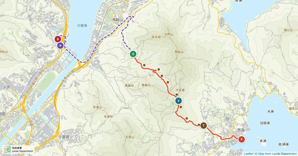
- 泽祥街 → 大老山公路 → 马鞍山路 → 马鞍山村路上山,见下方地图上的紫色虚线 Chak Cheung Street → Tate’s Cairn Highway → Ma On Shan Road → up Ma On Shan Tsuen Road; see the purple dashed line on the map Chak Cheung Street → Tate’s Cairn Highway → Ma On Shan Road → Ma On Shan Tsuen Road로 올라감 (지도의 보라색 점선) Chak Cheung Street → Tate’s Cairn Highway → Ma On Shan Road → montée par Ma On Shan Tsuen Road (pointillés violets sur la carte)
- 车费估计每车 HK$80–100 Estimated fare HK$80–100 per car 예상 요금 1대당 HK$80–100 Course estimée à 80–100 HK$ par voiture
- 每车最多 4 位乘客,请备现金或八达通 Up to 4 passengers per car; bring cash or an Octopus card 1대당 승객 최대 4명, 현금이나 옥토퍼스 카드 준비 4 passagers maximum ; prévoyez des espèces ou une carte Octopus
- 下车后在烧烤场等齐全部人再出发 At the drop-off, wait until every car has arrived 도착 후 모든 택시가 올 때까지 바비큐장에서 대기 À l’arrivée, attendez que toutes les voitures soient là
馬鞍山郊野公園燒烤場
Ma On Shan Country Park Barbecue Site · 22.4086, 114.2364 · Google Maps
路线The route코스L’itinéraire
可拖动、双指或 +/− 缩放,点标记看详情。H 是沙田凯悦酒店(集合点),B 是港铁大学站 B 出口,S 是徒步起点,P 是西贡公众码头,棕色小牌是标距柱。打车路线只供参考,司机可能走别的路。在下方海拔图上移动,地图上的黄点会跟着走。 Drag to pan, pinch or use +/− to zoom, tap a marker for details. H is the Hyatt (meeting point), B is University station Exit B, S is the trailhead, P is Sai Kung Public Pier, brown tags are distance posts. The taxi line is a suggestion; drivers may take another road. Move along the elevation chart below and the yellow dot follows on the map. 드래그로 이동하고, 두 손가락이나 +/−로 확대·축소하며, 표시를 누르면 상세 정보가 나옵니다. H는 하얏트 호텔(집합 장소), B는 MTR University역 B 출구, S는 하이킹 출발점, P는 사이쿵 공공 부두, 갈색 표는 거리 표지주입니다. 택시 경로는 참고용이며 기사가 다른 길로 갈 수 있습니다. 아래 고도 그래프 위를 움직이면 지도의 노란 점이 따라 움직입니다. Faites glisser pour vous déplacer, pincez ou utilisez +/− pour zoomer, touchez un repère pour les détails. H : Hyatt (point de rendez-vous) ; B : sortie B de la station University ; S : départ de la randonnée ; P : embarcadère de Sai Kung ; étiquettes brunes : bornes. Le trajet en taxi est indicatif, le chauffeur peut en prendre un autre. Parcourez le profil ci-dessous : le point jaune suit sur la carte.
棕色小方块是沿途的标距柱 C3301–C3308,约每 500 米一根 The brown squares are the trail’s distance posts C3301–C3308, roughly one every 500 m 갈색 사각형은 거리 표지주 C3301–C3308로, 약 500 m마다 하나씩 있습니다 Les carrés bruns sont les bornes kilométriques C3301–C3308, environ tous les 500 m
烧烤场 → 昂平高原BBQ site → Ngong Ping plateau바비큐장 → 옹핑 고원Site de barbecue → plateau de Ngong Ping
↑ ≈180 m 稳步上坡。前 1.5 公里比较缓,最陡的一段在 km 1.8–2.3,快到高原时要多爬约 80 米,按自己节奏走就好。 A steady climb. The first 1.5 km is gentle; the steepest stretch is km 1.8–2.3, about 80 m of climbing just before the plateau. Take it at your own pace. 꾸준한 오르막입니다. 처음 1.5 km는 완만하고, 가장 가파른 구간은 고원 직전 km 1.8–2.3으로 약 80 m를 오릅니다. 자기 속도로 걸으세요. Montée régulière. Les 1,5 premiers km sont doux ; le passage le plus raide se situe entre les km 1,8 et 2,3, environ 80 m de montée juste avant le plateau. Allez à votre rythme.
昂平高原 · 昂平观景台Ngong Ping plateau and viewpoint옹핑 고원 · 옹핑 전망대Plateau et belvédère de Ngong Ping
≈390 m 海拔约 390 米的大草原,基本是平路。观景台在 km 2.8 左右,可以看到马鞍山郊野公园和西贡海,是全程最好的休息拍照点。草原没有遮挡,注意防晒。 Open grassland at about 390 m, almost flat. The viewpoint is around km 2.8, looking over the country park and the Sai Kung sea: the best stop for a rest and photos. There is no shade up here, so cover up from the sun. 해발 약 390 m의 넓은 초원으로 거의 평지입니다. km 2.8 부근 전망대에서 컨트리파크와 사이쿵 바다가 한눈에 보여 휴식과 사진 찍기에 가장 좋습니다. 그늘이 없으니 햇볕에 주의하세요. Grande prairie vers 390 m, presque plate. Le belvédère, vers le km 2,8, domine le parc et la mer de Sai Kung : c’est la meilleure halte pour se reposer et prendre des photos. Aucune ombre : protégez-vous du soleil.
下山到大水井Descent to Tai Shui Tseng타이쉬청까지 하산Descente vers Tai Shui Tseng
↓ ≈250 m 注意湿滑Slippery미끄럼 주의Glissant 1.3 公里内下降约 250 米,平均坡度约 20%,是全程最需要小心的一段。周六下过雨,石级和泥地可能还是湿的,放慢脚步,有登山杖就用上。大水井是郊游径终点。 About 250 m down in 1.3 km, an average gradient near 20%. This is the part that needs the most care. After Saturday’s rain the steps and dirt may still be wet, so slow down and use poles if you have them. Tai Shui Tseng marks the end of the country trail. 1.3 km 동안 약 250 m를 내려가며 평균 경사는 약 20%로, 가장 조심해야 할 구간입니다. 토요일 비로 돌계단과 흙길이 젖어 있을 수 있으니 천천히 걷고, 스틱이 있으면 사용하세요. 타이쉬청이 트레일 종점입니다. Environ 250 m de descente sur 1,3 km, soit une pente moyenne proche de 20 % : c’est la section la plus délicate. Après la pluie de samedi, marches et terre peuvent rester humides ; ralentissez et utilisez des bâtons si vous en avez. Tai Shui Tseng marque la fin du sentier officiel.
大水井 → 西贡公众码头Tai Shui Tseng → Sai Kung Public Pier타이쉬청 → 사이쿵 공공 부두Tai Shui Tseng → embarcadère public de Sai Kung
↓ ≈130 m 郊游径之外多走的 1.7 公里,从海拔约 130 米一路下到海边,后半段是村路和市区马路。过马路时注意车辆,队伍不要拉太长。 An extra 1.7 km beyond the official trail, dropping from about 130 m to the sea. The second half follows village lanes and town streets. Watch for traffic when crossing roads and keep the group together. 공식 트레일 밖으로 1.7 km를 더 걸어 해발 약 130 m에서 바닷가까지 내려갑니다. 후반은 마을길과 시내 도로이니 길을 건널 때 차량에 주의하고 일행과 떨어지지 마세요. 1,7 km en plus du sentier officiel, de 130 m d’altitude environ jusqu’à la mer. La seconde moitié emprunte des ruelles de village puis les rues de la ville : attention à la circulation et restez groupés.
天气与装备Weather and what to bring날씨와 준비물Météo et équipement
11 月中旬香港白天一般 20–26°C,晴天紫外线仍然强。起点烧烤场有洗手间,途中几乎没有设施,也没有商店,到西贡才能买东西。 Mid-November days in Hong Kong are usually 20–26°C, and the sun is still strong. There are toilets at the barbecue site; along the trail there are almost no facilities and no shops until Sai Kung. 11월 중순 홍콩 낮 기온은 보통 20–26°C이고 맑은 날은 자외선이 여전히 강합니다. 출발점 바비큐장에 화장실이 있으며, 코스 중간에는 시설과 상점이 거의 없어 사이쿵에 도착해야 물건을 살 수 있습니다. À la mi-novembre, il fait généralement 20 à 26 °C en journée à Hong Kong et le soleil reste fort. Il y a des toilettes au site de barbecue ; ensuite, presque aucun équipement ni magasin avant Sai Kung.
- 饮用水 1–1.5 升1–1.5 L of water물 1–1.5 L1 à 1,5 L d’eau
- 防滑运动鞋或登山鞋Trainers or hiking shoes with grip접지력 좋은 운동화나 등산화Baskets ou chaussures de randonnée antidérapantes
- 帽子、太阳镜、防晒霜Hat, sunglasses, sunscreen모자, 선글라스, 선크림Chapeau, lunettes de soleil, crème solaire
- 轻便雨衣或风衣Light rain or wind jacket가벼운 우비나 바람막이Veste de pluie ou coupe-vent léger
- 零食、能量补给Snacks간식En-cas
- 手机充满电,带充电宝Charged phone and a power bank충전된 휴대폰과 보조배터리Téléphone chargé et batterie externe
- 八达通或现金(打车、公共交通)Octopus card or cash (taxi, public transport)옥토퍼스 카드나 현금 (택시, 대중교통)Carte Octopus ou espèces (taxi, transports en commun)
- 个人药物、纸巾、垃圾袋Personal medicine, tissues, a rubbish bag개인 상비약, 휴지, 쓰레기봉투Médicaments personnels, mouchoirs, sac poubelle
- 可选:登山杖Optional: trekking poles선택: 등산 스틱Facultatif : bâtons de marche
- 可选:替换上衣,午饭前换上Optional: a dry shirt for lunch선택: 점심 전 갈아입을 여벌 상의Facultatif : un t-shirt sec pour le déjeuner
GPX 轨迹与导航GPX track and navigationGPX 트랙과 내비게이션Trace GPX et navigation
这条轨迹从烧烤场一直到西贡公众码头(6.3 公里),带起点、终点和 C3301–C3308 标距柱航点,可以导入佳明等运动手表或 Tooboo 这类行山 App。请在酒店 Wi-Fi 下提前导入,山上信号可能不稳定。 The track runs from the barbecue site all the way to Sai Kung Public Pier (6.3 km), with waypoints for the start, finish and distance posts C3301–C3308. Load it onto a Garmin or other sports watch, or into a hiking app such as Tooboo. Do it on hotel Wi-Fi beforehand; mobile signal on the hill can be patchy. 이 트랙은 바비큐장부터 사이쿵 공공 부두까지(6.3 km)이며 출발점, 도착점, C3301–C3308 표지주 웨이포인트가 들어 있습니다. 가민 등 스포츠 워치나 Tooboo 같은 하이킹 앱에 넣어 쓰세요. 산에서는 신호가 약할 수 있으니 호텔 Wi-Fi에서 미리 받아 두세요. La trace va du site de barbecue jusqu’à l’embarcadère public de Sai Kung (6,3 km), avec des points de passage pour le départ, l’arrivée et les bornes C3301–C3308. Chargez-la sur une montre Garmin ou une autre montre sport, ou dans une appli de randonnée comme Tooboo. Faites-le à l’avance sur le Wi-Fi de l’hôtel : le réseau peut être faible en montagne.
Tooboo 或其他行山 AppTooboo or another hiking appTooboo 또는 다른 하이킹 앱Tooboo ou une autre appli
- 在 iPhone 上安装 Tooboo Install Tooboo on your iPhone iPhone에 Tooboo 설치 Installez Tooboo sur votre iPhone
- 在“文件”App 里点开 GPX,用分享菜单发送到 Tooboo(或在 App 内选择导入轨迹) Open the GPX in the Files app and use the Share menu to send it to Tooboo (or import the track from inside the app) 파일(Files) 앱에서 GPX를 연 뒤 공유 메뉴로 Tooboo에 보내기 (또는 앱 안에서 트랙 가져오기) Ouvrez le GPX dans l’app Fichiers et partagez-le vers Tooboo (ou importez la trace depuis l’appli)
- 下载离线地图,当天打开导航 Download the offline map and start navigation on the day 오프라인 지도를 받아 두고 당일 내비게이션 시작 Téléchargez la carte hors ligne et lancez la navigation le jour J
其他支持 GPX 的 App(如 AllTrails、Outdooractive)同样可以导入 Any other app that reads GPX (AllTrails, Outdooractive and so on) works too AllTrails, Outdooractive 등 GPX를 지원하는 다른 앱도 사용할 수 있습니다 Toute autre appli compatible GPX (AllTrails, Outdooractive…) convient aussi
佳明 Garmin 手表Garmin watch가민(Garmin) 워치Montre Garmin
- 电脑打开 Garmin Connect 网页版,进入“训练与计划 → 路线” Open Garmin Connect on the web and go to Training & Planning → Courses PC에서 Garmin Connect 웹을 열고 Training & Planning → Courses로 이동 Ouvrez Garmin Connect sur le web, rubrique Entraînement et planification → Parcours
- 点“导入”,选择 GPX 文件,保存路线 Click Import, choose the GPX file and save the course Import를 눌러 GPX 파일을 선택하고 코스를 저장 Cliquez sur Importer, choisissez le fichier GPX et enregistrez le parcours
- 点“发送到设备”,同步手表 Choose Send to Device and sync the watch Send to Device를 눌러 워치와 동기화 Choisissez Envoyer vers l’appareil et synchronisez la montre
- 当天在手表上:开始徒步活动 → 导航 → 路线 → 选这条路线 On the day: start a Hike activity → Navigation → Courses → pick this course 당일 워치에서: 하이킹 활동 시작 → Navigation → Courses → 이 코스 선택 Le jour J : activité Randonnée → Navigation → Parcours → choisir ce parcours
菜单名称因型号和语言略有不同 Menu names vary slightly by model and language 메뉴 이름은 모델과 언어 설정에 따라 조금 다를 수 있습니다 Les noms de menus varient selon le modèle et la langue
安全Safety안전Sécurité
香港紧急电话,手机也可拨 112。报告位置时说出最近的标距柱编号,例如 C3305,救援人员能马上定位。 Hong Kong emergency number; 112 also works from mobiles. To give your location, read out the nearest distance post, for example C3305; rescuers can find it immediately. 홍콩 긴급 전화이며 휴대폰으로는 112도 됩니다. 위치를 알릴 때 가장 가까운 거리 표지주 번호(예: C3305)를 말하면 구조대가 바로 찾을 수 있습니다. Numéro d’urgence de Hong Kong ; le 112 fonctionne aussi depuis un mobile. Pour indiquer votre position, donnez le numéro de la borne la plus proche, par exemple C3305 : les secours la localisent tout de suite.
- 领队在前、收队在后,不要超过领队,也不要落在收队后面。 The leader walks in front and a sweeper at the back. Stay between them. 인솔자가 앞에, 후미 담당이 맨 뒤에 섭니다. 그 사이에서 걸어 주세요. Un guide ouvre la marche, un serre-file la ferme : restez entre les deux.
- 身体不舒服、抽筋或跟不上,马上告诉身边的人。 If you feel unwell, get cramp or can’t keep up, tell someone near you right away. 몸이 안 좋거나 쥐가 나거나 따라가기 힘들면 바로 주변 사람에게 알려 주세요. En cas de malaise, de crampe ou de difficulté à suivre, prévenez immédiatement vos voisins.
- 只走有路标的主路,下坡湿滑路段慢慢走。 Stay on the signposted path and take the wet descent slowly. 표지가 있는 주 등산로로만 걷고, 젖은 내리막은 천천히 내려가세요. Restez sur le sentier balisé et descendez lentement les passages humides.
- 秋冬是山火高危期,郊野公园内不要吸烟,只能在指定烧烤炉生火。 Autumn and winter are hill-fire season: no smoking in the country park, and fires only in designated barbecue pits. 가을·겨울은 산불 위험이 높은 시기입니다. 컨트리파크 안에서는 흡연하지 말고, 불은 지정된 바비큐 화덕에서만 피울 수 있습니다. L’automne et l’hiver sont la saison des feux de colline : interdiction de fumer dans le parc, feux uniquement dans les foyers de barbecue prévus.
- 垃圾自己带走,不要喂野生动物。 Take your litter with you and don’t feed wild animals. 쓰레기는 되가져가고 야생동물에게 먹이를 주지 마세요. Remportez vos déchets et ne nourrissez pas les animaux sauvages.
午餐与回程Lunch and getting back점심과 귀가Déjeuner et retour
西贡公众码头一带的海旁有很多海鲜酒家和茶餐厅,午饭就在码头附近解决。 The waterfront around Sai Kung Public Pier is lined with seafood restaurants and cha chaan teng cafés; we’ll eat near the pier. 사이쿵 공공 부두 주변 해안가에는 해산물 식당과 홍콩식 카페(차찬텡)가 많아 부두 근처에서 점심을 먹습니다. Le front de mer autour de l’embarcadère de Sai Kung regorge de restaurants de fruits de mer et de cha chaan teng (cafés hongkongais) : nous déjeunerons près de l’embarcadère. Google Maps
回沙田凯悦酒店Back to the Hyatt, Sha Tin하얏트 샤틴으로 돌아가기Retour au Hyatt, Sha Tin
- 打车最省心:约 15 公里、25–30 分钟,车费估计每车 HK$150–170(经西沙路、马鞍山,不过隧道) Taxi is the simplest: about 15 km and 25–30 minutes, estimated HK$150–170 per car (via Sai Sha Road and Ma On Shan, no tunnel) 택시가 가장 편합니다: 약 15 km·25–30분, 예상 요금 1대당 HK$150–170 (Sai Sha Road·마온산 경유, 터널 없음) Le taxi est le plus simple : environ 15 km et 25 à 30 minutes, course estimée à 150–170 HK$ par voiture (par Sai Sha Road et Ma On Shan, sans tunnel)
- 九巴 299X 往沙田市中心,到沙田站转东铁线(往罗湖/落马洲方向)到大学站 KMB bus 299X to Sha Tin Central, then the East Rail Line northbound (towards Lo Wu / Lok Ma Chau) to University KMB 버스 299X로 Sha Tin Central까지 간 뒤, 샤틴역에서 이스트 레일 선(Lo Wu / Lok Ma Chau 방향)으로 University역 Bus KMB 299X jusqu’à Sha Tin Central, puis East Rail Line vers le nord (direction Lo Wu / Lok Ma Chau) jusqu’à University
- 或九巴 92 往钻石山站,转屯马线到大围,再转东铁线(往罗湖/落马洲方向)到大学站 Or KMB bus 92 to Diamond Hill, then the Tuen Ma Line to Tai Wai and the East Rail Line northbound to University 또는 KMB 버스 92로 Diamond Hill역까지 간 뒤, 툰마 선으로 Tai Wai역, 이스트 레일 선(북쪽 방향)으로 University역 Ou bus KMB 92 jusqu’à Diamond Hill, puis Tuen Ma Line jusqu’à Tai Wai et East Rail Line vers le nord jusqu’à University
去九龙 / 市区To Kowloon / the city까우룽 / 시내 방면Vers Kowloon / le centre
- 绿色专线小巴 1A 到港铁彩虹站(观塘线) Green minibus 1A to Choi Hung MTR station (Kwun Tong Line) 초록색 미니버스 1A로 MTR Choi Hung역 (쿤통 선) Minibus vert 1A jusqu’à la station MTR Choi Hung (Kwun Tong Line)
- 九巴 92 到港铁钻石山站(观塘线、屯马线) KMB bus 92 to Diamond Hill MTR station (Kwun Tong and Tuen Ma lines) KMB 버스 92로 MTR Diamond Hill역 (쿤통 선·툰마 선) Bus KMB 92 jusqu’à la station MTR Diamond Hill (Kwun Tong Line et Tuen Ma Line)
- 班次以现场和 Google Maps、Citymapper 等 App 为准 Check times on the spot or in Google Maps / Citymapper 운행 시간은 현장이나 Google Maps, Citymapper 앱에서 확인 Vérifiez les horaires sur place ou dans Google Maps / Citymapper
沙田凱悅酒店
Hyatt Regency Hong Kong, Sha Tin · 18 Chak Cheung Street · 22.4113, 114.2112 · Google Maps